- Free shipping from 220€The order of accessories (without BikeTrax) is excluded from the free shipping costs.
PowUnity explains, Top, Topics
How GPS Tracking works
Inhalt
About GPS tracking in a nutshell
- The Global Positioning System is a satellite navigation system that was originally developed for military purposes. Today, GPS systems are widely used in the civilian sector.
- GPS tracking is used to locate objects. There is a difference between passive and active tracking. Only with the latter is it possible to locate moving objects in real time.
- Mini GPS trackers are ideal for tracking down and recovering a stolen e-bike, for example. However, there is a big difference between a real GPS tracker like BikeTrax from PowUnity and gadgets like Apple’s AirTag, which work with Crowd GPS.
Whether driving, cycling or hiking, in agriculture, mining or the financial system, GPS now affects almost every aspect of our lives. But how does the technology that we take for granted in sat navs or when using Google Maps work, and how was it developed? Here we take a look at the secrets of GPS technology. We focus on its function in the mobility sector.
What is GPS Tracking: A Definition of the Global Positioning System
What is GPS?
GPS (Global Positioning System), officially NAVSTAR GPS, is a worldwide radio navigation system that is currently supported by 24 satellites 6 and their ground stations. The system was originally developed exclusively for military purposes. Today, any civilian user can access GPS signals without any fees or restrictions.
GPS tracking uses satellites that use microwave signals. These waves provide information about the position, speed or direction of objects on earth – one reason why GPS does not work in tunnels, for example.
Understanding GPS Tracking
GPS tracking is a method of determining and monitoring the exact location of something. A GPS tracker 2 contains a GPS receiver that collects signals and calculates the coordinates of the object 1 to be located. These are transmitted via an internet connection 4 through cellular, Wi-Fi, or radio frequencies 3 . A tracking system can be attached to a vehicle or cell phone, for example, and can be permanently installed or portable.
✓
GPS tracking is a method that involves finding out the exact location of something and to monitor it.
The BikeTrax GPS tracker from PowUnity, for example, determines the real-time location of e-bikes and records routes traveled. With its help and the PowUnity app, you can track down lost or stolen e-bikes.
From GPS Satellites and Navigation systems – the History of the GPS Tracking System
The US Air Force initially developed GPS with the aim of improving its military operations. It replaced radio navigation systems such as LORAN and DECCA .
✓
The US government owns and operates the GPS network, which was originally developed for military purposes.
The development of GPS began in 1958, when Soviet experts sent the first satellite called Sputnik into space. Scientists at MIT observed that the satellite’s radio frequencies changed depending on its location. This Doppler effect, the changing frequency emission of satellites, gave them the idea that the position of a satellite along its orbit around the earth could be tracked or traced directly from the ground by calculating the radio frequency variations of a signal.
TRANSIT and ESTIMATION
The first navigation satellite system TRANSIT
US Navy scientists developed the first navigation satellite system, called TRANSIT. Now the navy could locate its submarines equipped with nuclear missiles. The TRANSIT technology used five constellation satellites. The system was first successfully put into practice in 1960.
The ESTIMATION technology
Five to six years after the implementation of TRANSIT, the US Navy, with the help of MIT scientists, developed another satellite called ESTIMATION. This satellite made it possible to place precise clocks in space. GPS is still based on ESTIMATION technology today. In the early 1970s, Omega was developed, the world’s first ground-based navigation system, which was the first radio navigation system to be implemented and put into operation. Later, Rockwell International launched the Block I GPS satellite. In 1983, after a Soviet interceptor shot down a civilian airplane that had strayed into restricted Soviet airspace. Afterwards, the US president announced that GPS tracking devices could be used by everyone as soon as they became available.
NAVSTAR and the first GPS Satellite
Eventually, private technology companies such as Aerospace began to help the US military develop another satellite in orbit that would constantly receive and continuously transmit signals from the ground. After ten years of development, the US Air Force launched the first satellite of the 24-satellite tracking system NAVSTAR, or GPS as it is known today.
For a long time, the GPS system was only approved for civilian use with limited accuracy. An interference signal reduced this to around 100 meters. It was not until 2000 that the selective GPS availability was lifted.
In the course of time, the number of active, oscillating satellites and the reserve inventory was also steadily increased and the accuracy of the GPS improved. Scientists, private companies and the US Department of Defense developed a growing number of GPS-based applications.
How does GPS work?
GPS uses the mathematical principle of trilateration. In order for the GPS to perform mathematical calculations, it must know at least two aspects:
-
the current location of the person, object or vehicle, which is targeted by at least three satellites and
-
the distance or current range between the object to be tracked and the tracking point.
One GPS satellite is not sufficient to obtain information about the exact location of a moving object. At least three GPS satellites are required, in many cases even at least four.
GPS receivers usually record the position of an object as it moves from one point to another.
A GPS tracker basically has two functions:
-
storing the recorded data on the device itself (passive tracking) and
-
regularly sending the recorded data to a central system via a modem attached to the GPS device (active positioning).
Different Types of Global Positioning System
Passive Global Positioning System
The passive global positioning system monitors the location of a moving vehicle based on certain driving events. Passive GPS direction finders, for example, record the locations that the vehicle has passed in the previous hours. The information is stored on the internal memory or on an external device such as a memory card and later transferred to a computer for analysis. Sometimes stored data is automatically sent via the Internet and downloaded at a specific point or retrieved while driving.
Active Global Positioning System
With active GPS (live tracking), for example, a GPS-enabled tracking device is installed on a car to collect tracking information to determine its position and transmit it via a satellite or cellular network.
✓
With active GPS, objects can be tracked in real time.
If the cellular network is not available, the GPS transmitter stores the data and transmits it to the server as soon as the cellular network is available again. Real-time tracking applications are ideal for theft protection. They can be used, for example, to pinpoint the exact location of stolen vehicles.
Mini GPS Tracker
“Mini GPS tracker” is a popular term for trackers of the active Global Positioning Aystem. Mini GPS trackers are often used in security applications, for example to monitor people, children or pets or to protect vehicles such as trucks, cars or bicycles from theft. With older models, the position coordinates were transmitted via SMS. Modern devices communicate with the user via a smartphone app.
The PowUnity BikeTrax GPS-tracker is therefore an active tracking unit that makes it possible for the owner to see the real time location of an e-bike – from everywhere and at any time. After the subscription in the app the customer can see his e-bike on a live map andevery driven route in the route diary. The route diary is one of the app features and is an automatic service. Every GPS location is being saved and sent to the mobile phone every tenth second. Additionally the GPS tracking device is also a theft protection that sends an alert to the smartphone app in case of unauthorized change of the GPS location. The PowUnity customer can decide between a monthly or an annual subscription to use GPS data and the provided tools and features.
GPS Tracker for People and Animals
A mini GPS tracker for people, children or animals should be handy, light and above all inconspicuous, as it has to be worn. Devices that are attached to the collar of (pets) animals should also be waterproof if the pets spend a lot of time outdoors. Tractive is such a GPS tracker for dogs and cats. It is waterproof and inconspicuous. One of its most important functions is the “virtual fence” (geo-fence): The owner receives a notification when the pet leaves a defined area (e.g. the garden).
Vehicle Tracker
A mini GPS tracker is also an ideal anti-theft device for tracking stolen vehicles. Equipped with a SIM card and lightweight electronics, it should be no more than around seven to eight centimeters in size. It can even be fitted in the rear lights of trucks. If a mini GPS tracker is integrated into vehicles, the likelihood of the tracker being detected decreases.
But it’s not just the size that matters. One of the most important quality features is the battery life of a tracker. The smaller the device, the smaller the battery, the shorter the battery life. If the GPS tracker is not connected to a power source, the battery will need to be recharged after a few hours or days. The situation is different with mini GPS trackers that are integrated into a car or e-bike and are powered directly by its battery.
E-bike Tracker using the Example of BikeTrax
The PowUnity BikeTrax GPS tracker allows you to track and locate your e-bike in real time – from anywhere and at any time. After logging into the app, you can see the live position of your e-bike on a map and every route you have ridden in the logbook. Your location is sent to your cell phone every ten seconds. In the event of unauthorized movement of the e-bike, the tracker sends a push notification and a movement alarm to the app.
The PowUnity BikeTrax GPS tracker is permanently installed in the motor compartment of e-bikes. The BikeTrax has a battery life of around three weeks in standby mode. To ensure uninterrupted reception, it is also equipped with an additional rechargeable battery.
The term mini GPS tracker is often, albeit incorrectly, used for coin-sized “all-round finders”, so-called Bluetooth tracking chips. The name of the technology behind it, Crowd GPS, is misleading, as these all-round finders have nothing in common with the NAVSTAR GPS. Unlike a real mini tracker, they are not equipped with a SIM card for data transmission to the cell phone app, nor do they use at least three or at least four satellites to determine the vehicle’s location.
What really matters when it comes to mini GPS trackers for theft protection and how do you find the best device for your needs? You can find answers to these questions in our article “GPS Tracker Bike: Test Check”.
The interaction of GPS Trackers and Tracking Apps
Tracking apps establish a connection between a GPS transmitter and a smartphone. The tracker does not communicate directly with the owner’s cell phone, but sends the data to an intermediary server. This forwards the data to the GPS app on the cell phone. The receiver attached to vehicles such as cars or e-bikes helps the owner of the corresponding cell phone with the tracking app to determine the exact position of their vehicle or to view its route if they are involved in an accident or the vehicle is stolen.
✓
The 2G mobile phone standard is currently the most suitable for vehicle tracking, as it has extensive network coverage throughout Europe.
The GPS signal is transmitted to the smartphone via mobile phone standards of different generations such as 2G, 3G, 4G (second, third and fourth generation) etc. GPRS and LTE are the designations for data transmission within these generations. GPRS is the data transmission within the 2G standard and LTE stands for data transmission within the 4G standard.
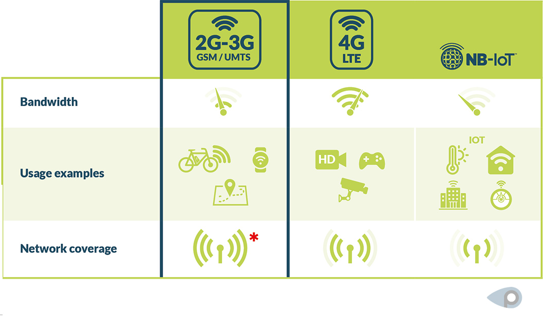
The 2G standard has been around since the 1990s. It has a very high network density and is currently the most suitable technology for protecting vehicles such as e-bikes from theft. In contrast to 2G, narrowband IoT technology has not yet been expanded across the board. It can have dead spots, especially in rural areas.
In the case of BikeTrax, transmission to the cell phone takes place via the 2G standard – currently the best solution for locating e-bikes and therefore also for digital theft protection for e-bikes. The receiver is hidden in the bike’s motor. A SIM card is integrated into it. An additional battery ensures that the GPS tracker continues to receive and send an alarm in an emergency if the power supply (e.g. from the e-bike battery) is switched off or removed.
Summary
With GPS tracking, information about the exact position of a vehicle or person is transmitted via mobile radio, Wi-Fi or radio frequencies. The tracking itself works with a radio navigation system that is currently supported by around 24 satellites and their ground stations. GPS trackers are able to provide previous (passive) and real-time (active) navigation information about a journey. A mini GPS tracker is part of the active global positioning system (real-time GPS tracking). It is particularly suitable for locating people or animals as well as for theft protection of vehicles such as trucks, cars or e-bikes. The size of the GPS receiver determines its battery life.
Tracking apps establish a connection between a tracking device and the SIM card of a cell phone. In the case of BikeTrax, the tracker sends a movement alarm to the PowUnity app if the e-bike moves without permission. The location of the BikeTrax is transmitted to the smartphone via the 2G mobile phone standard. 2G technology is currently the most stable and comprehensive network and is therefore ideal for protecting e-bikes from theft.
✓
With GPS tracking apps, we are able to query the exact location of vehicles, devices, etc. at any time via smartphone.
A key advantage of GPS receivers is that they can be used to better secure assets. They are also important for navigation. Companies can use GPS tracking to optimize their processes. However, GPS receivers are dependent on data from at least three satellites, usually even four. Without sufficient satellite signals, real-time positioning is not possible.
FAQs GPS Tracking
How does GPS work?
GPS stands for Global Positioning System and is a radio navigation system with currently 24 satellites. GPS positioning involves at least three satellites, ideally at least four. A GPS receiver uses radio waves and time measurement to calculate the distance to these satellites. Based on this, it determines its own position. This information is transmitted to a cell phone, for example. Navigation devices use GPS to determine their position.
What is the difference between a GPS receiver and a GNSS receiver?
GNSS is the abbreviation for Global Navigation Satellite System and refers to the entirety of all global satellite positioning systems. GPS is one part of GNSS. Another is the Russian GLONASS system, for example.
What are mini GPS trackers suitable for?
Mini GPS trackers are ideal for theft protection. BikeTrax from PowUnity, for example, is permanently integrated into the motor of e-bikes and connected to your smartphone via an app. This serves as a GPS receiver. In the event of an attempted theft, the app alerts you on your smartphone. You can also track a stolen e-bike in real time and pass the location data on to the police. You can find many examples of how our customers have recovered stolen bikes with the help of BikeTrax in our video collection with hits and success stories.
What requirements are important for successful e-bike tracking with a GPS receiver?
If you want to track your e-bike with GPS and protect it from theft, make sure that it is real GPS and not crowd GPS. The device should also be concealed, enable real-time tracking and be linked to a user-friendly app.
Share article!

 Deutsch